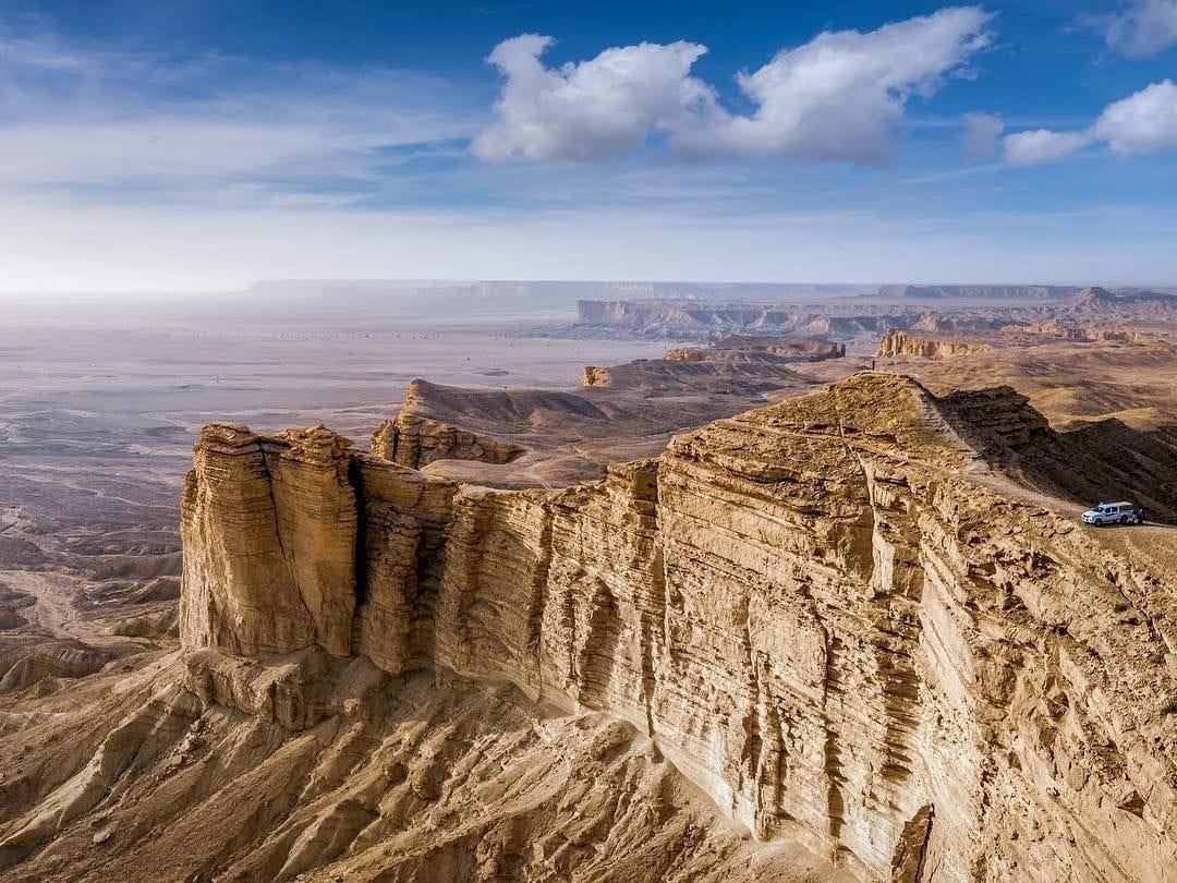
Hiking in Riyadh offers a unique way to explore Saudi Arabia’s capital, from dramatic escarpments and ancient trade routes to hidden wadis and geological wonders. In a city that welcomed over 20 million visitors in 2025 so far, outdoor adventures are becoming one of the top things to do in Riyadh for both international travelers and locals alike.
Here’s a curated guide to hiking trails in and around Riyadh, organized for ease, insight, and inspiration. Explore natural escapes that merge history, silence, and panoramic views.
1. Edge of the World (Jebel Fihrayn)
Distance: 2.4 km loop
Elevation gain: 538 ft
Difficulty: Easy
Highlights:
- Breathtaking views of the Tuwaiq Escarpment
- Walk along ancient seabed terrain and acacia trees
- Stunning spot for sunrise or sunset photography
→ Visit on weekdays to avoid crowds
→ Use a 4x4; police may restrict access beyond main parking
→ Pack sun protection, snacks, and plenty of water
How to Get There:
Located about 100 km from Riyadh, at the far end of the 800 km-long Tuwaiq Mountain range. Reaching the site requires a 4×4 vehicle due to rough dirt tracks.
2. Mugatiah Trail – Thadig National Park
Distance: 6.8 km loop (extendable)
Elevation gain: 269 ft
Difficulty: Moderate
Highlights:
- Part of a long-term eco-tourism initiative
- Waterfalls (seasonal), small caves, and desert vistas
- Well-maintained trail with signage and rest areas
Family-friendly and stroller-accessible in parts
Paved road access from Riyadh city
Best visited in late fall or winter
How to Get There:
Approximately 130 km north of Riyadh near Thadiq. All roads paved; trail starts inside Thadig National Park.
3. Khashm AlHosan Hiking Trail
Distance: 8.8 km loop
Elevation gain: 892 ft
Difficulty: Moderate
🦯🚁فلوق هايكنج خشم الحصان
— . mujahid. (@mog550) March 9, 2024
Hiking horse snout
اول تجربه كانت جميله ومتعه ما تنوصف
وهالاجواء الشرحه والزينه 😍
طول المسار ذهاب وعودة 9 كيلو
المسار مريح وسلسل واهم شي تزبط وضعك في هالمهمه من التجهيزات اللي تحتاجها
الطريق للوصول الى نقطه المسار ممهد وزين والسيارات الصغيره توصل https://t.co/RZGETB5Cem pic.twitter.com/2kODHZX1Ig
Highlights:
- Climbs to the summit of Khashm Al-Hosan Mountain
- Expansive views of plateaus and desert ridges
- Ideal for sunrise or sunset hikes
- Quiet, scenic trail with a mix of rocky and sandy sections
→ Moderate fitness needed; pace yourself on the incline
→ Bring plenty of water, sun protection, and good hiking shoes
→ Best hiked in cooler months (October to March)
How to Get There:
Approximately 90 km northwest of Riyadh near Raghabah. Take Route 65 north, then follow local roads toward the escarpment. A 4×4 is recommended for gravel access near the trailhead.
4. Camel Trail 1 - Riyadh Camel Trade Way
Distance: 1.3 km one way (2.6 km round trip)
Elevation gain: ~250 ft
Difficulty: Moderate
Highlights:
- Follows an ancient camel caravan route carved into the Tuwaiq escarpment
- Stone-built steps and terraces with sweeping desert views
- Peaceful, uncrowded, and ideal for sunrise or sunset hikes
- Cultural experience connecting you to Saudi Arabia’s trading past
→ Hike is short but requires fitness for the return climb
→ Carry water and wear proper hiking shoes, no shade along the trail
→ Great for families with older kids; picnic areas near the parking spot
→ Trail is visible and easy to follow, but terrain can be rocky in sections
How to Get There:
Approximately 50 km south of Riyadh. 2WD possible with care; 4×4 recommended for comfort.
5. Wadi Hanifah Trail
Distance: 8 km loop (extendable)
Difficulty: Easy
Highlights:
- Flowing water, green trees, and abundant birdlife
- Walk to Sultanah Promenade or Stone Dam Park
- A peaceful escape within city limits
→ Ideal for families or beginners
→ Bring a picnic or cycle along extended trails
→ Expect mixed-use paths with runners, walkers, and cyclists
How to Get There:
Located within Riyadh. Entry via Wadi Hanifah Road near Diplomatic Quarter, Sultanah, or Diriyah.
6. Hidden Valley Trail (Hidden Canyon)
Distance: ~8 km (varies)
Difficulty: Moderate
Highlights:
- Remote canyon with cliffs, sand valleys, and hidden water pools
- Popular with local guides and weekend campers
- Stunning for golden hour photography and star-gazing
→ Go with a local guide or trusted hiking group
→ Bring food, water, and overnight gear if staying
→ Avoid the hottest summer months
How to Get There:
Approximately 1 hr southwest of Riyadh via Dirab Road (Route 539). Gravel road ends near canyon entrance. 4×4 recommended.
7. Heet Cave Trail
Distance: ~1 km to cave entrance + 390m inside
Difficulty: Moderate
Highlights:
- Limestone cave with underground lake
- Cool, shaded environment, perfect for hot days
- A rare geological experience near Riyadh
→ Wear gloves and non-slip shoes
→ Bring a headlamp or flashlight
→ Avoid during rainy season, flooding risk
How to Get There:
Approximately 40 min southeast of Riyadh, off Al Kharj Road. Small parking area nearby; short walk to cave.
Let the Land Guide You!
From towering escarpments like the Edge of the World to hidden desert canyons and ancient caravan routes, each trail offers something unique: perspective, peace, and a story beneath your feet.
Whether you're a weekend explorer or planning your first hike in the Kingdom, take your time, stay safe, and tread respectfully. The trails around Riyadh are invitations to experience Saudi heritage, geology, and natural beauty up close.
